"Density Altitude" represents the altitude in the International Standard Atmosphere (ISA) where the air density would be the same as at the actual location, considering temperature and pressure variations. In simpler terms, density altitude is the altitude at which the aircraft "feels" as if it's flying, concerning its performance, rather than its actual physical altitude above sea level.
What does it affect? Think CALT: Climb Rate, Airspeed, Landing distance, Take-off distance. Climb rate will decrease as the temperature increases. The true airspeed will be higher due to increased temperature as well. Landing distance & Take-off distance will also increase incrementally with temperature. These combined is the perfect recipe for a disaster, but there is a way to avoid this:
Now, this is how I teach students in the 14 DAY ACCELERATED PRIVATE PILOT TRAINING PROGRAM by 14DAYPILOT Flight Academy on how to calculate density altitude and avoid disaster:
The density altitude (DA) is calculated using the following formula:
DA = PA + [120 x (OAT - ISA)]
Where:
- PA is the pressure altitude (the altitude corrected for non-standard pressure).
- OAT is the outside air temperature in degrees Celsius.
- ISA is the International Standard Atmosphere temperature for the given altitude.
To calculate density altitude, we first need to determine the pressure altitude. This can be done using a standard altimeter setting or by using actual pressure readings and a conversion chart.
Let's take Lake Tahoe as an example. The elevation of Lake Tahoe Airport (KTVL) is approximately 6,264 feet (1,909 meters) above sea level.
- Check the current altimeter setting (local barometric pressure) at Lake Tahoe Airport or nearby. Let's say it's 28.50 inches of mercury (Hg).
- Convert this setting to inches of mercury: 28.50 inHg.
- Use this value to find the pressure altitude using a conversion chart or formula. For simplicity, you can use an online calculator or chart. Let's assume the pressure altitude is calculated to be 7,000 feet.
- Find the current outside air temperature (OAT) at Lake Tahoe. Let's say it's 15°C.
- The ISA temperature decreases by approximately 2°C for every 1,000 feet increase in altitude. At 7,000 feet, the ISA temperature would be around 1°C.
- DA = 7,000 + [120 x (15 - 1)]
- DA = 7,000 + [120 x 14]
- DA = 7,000 + 1680
- DA ≈ 8,680 feet
In this example, this means that despite being at a physical altitude of 6,264 feet, the aircraft will perform as if it were at an altitude of 8,680 feet due to the combination of temperature and pressure effects on air density. Pilots must consider density altitude carefully to ensure safe take-offs, landings, and overall flight performance, especially in areas with high elevations like Lake Tahoe.
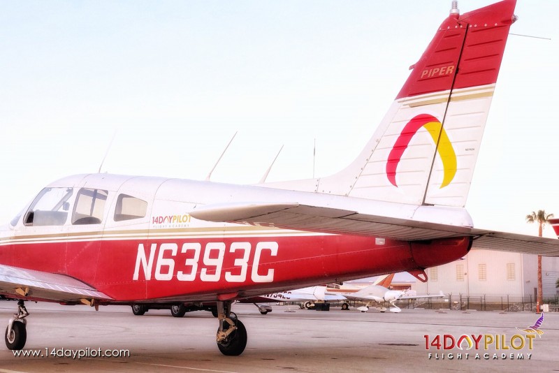
Now that we know the density altitude, let’s do the performance calculations for your flight back from Lake Tahoe with 2 friends. You’ll be flying the Piper Warrior II, we’ll do the Weight & Balance first. With 2 passengers, and 100 lbs of combined luggage & camp gear this is how it looks:
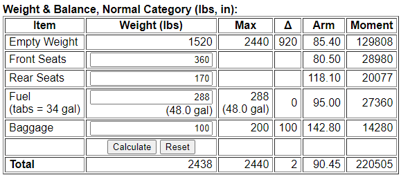
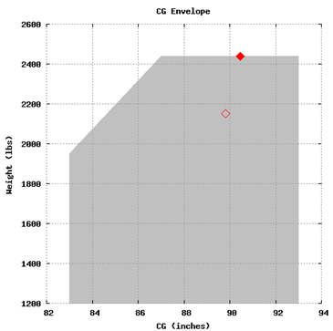
As you can see, you’ll be very close to your Maximum Takeoff Weight & on the limits of the Center of Gravity for the aircraft. Combined with the density altitude, this will affect the performance of the aircraft significantly.
Now, let’s do your takeoff calculations. You’re going to be on max takeoff weight, with a temperature of 15 degrees C, pressure altitude of 7000 ft, and density altitude close to 8680 feet. The performance charts for the Piper Warrior II are quite easy to use, you have to draw lines based on the information that you currently have, let’s take a look:
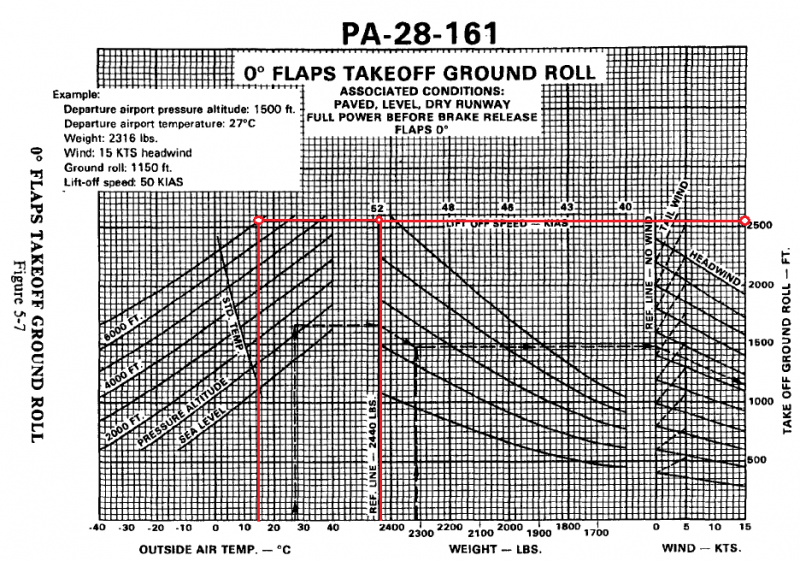
First, you’ll take the OAT of Lake Tahoe which is 15 degrees C, draw a line upwards to the 7000 ft pressure altitude, then draw a line upwards from your takeoff weight of 2438 lbs, then another line horizontally to connect both lines. At the point they are connected, you then draw another horizontal line all the way towards the right to find out takeoff ground roll is 2550 ft. And this is being optimistic, assuming there are no wind activities in Lake Tahoe! Next, you’ll have to do the climb rate calculations to 10,000 Ft to clear the mountains around Lake Tahoe.
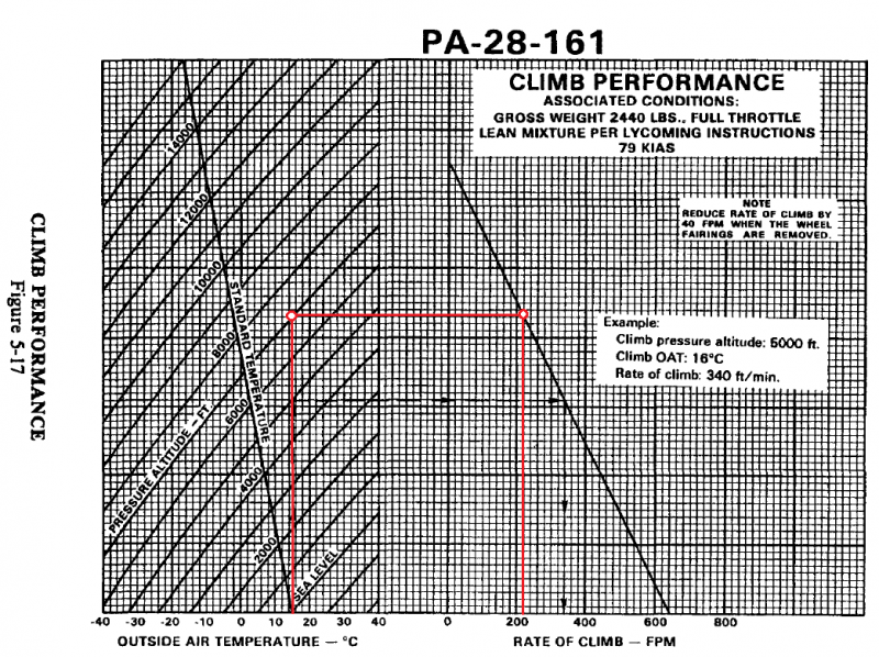
Same concept here, you’ll first draw a line upwards from 15 degrees C to our pressure altitude of 7000 Ft. Then horizontally to meet the reference line, and we get a climb rate of 220 Feet per Minute (FPM). Would you look at that! While we are able to takeoff from Lake Tahoe, it would certainly be hazardous to try clearing the mountains if we’re climbing at 220 FPM. This would immediately set off red flags for me to not do this flight & wait for better weather to get better performance before flying back. As the Pilot-in-Command (PIC) of this flight, I’ve made a decision that this flight is a NO GO due to poor climb performance. But let's take a look at the Time, Fuel and Distance to Climb chart:
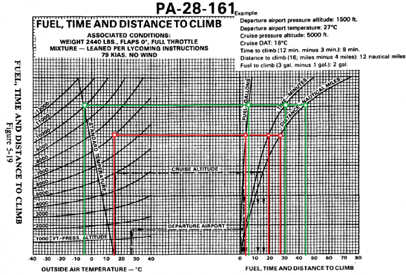
Same concept, but here we need to do 2 colored lines: First line (Red) is the departure airport calculation, Second line (Green) is for the cruising altitude. Let's do the departure airport first. I would first draw a line vertically from the 15 degrees C line since that is our temperature for Lake Tahoe, then meet the pressure altitude line of 7,000 Ft. After that, draw a horizontal line until the line intersects the Fuel, Time & Distance lines respectively. Mark the points at which our horizontal line intersects with the Fuel, Time & Distance lines, draw a line straight down to get the results. Do the same process for our cruising altitude of 10,000 Ft.
Departure Airport:
Fuel : 4 Gallons
Time : 20 Minutes
Distance : 28 NM (Nautical Miles)
Cruising Altitude:
Fuel : 6 Gallons
Time : 31 Minutes
Distance : 44 NM
Fuel : 6 Gallons - 4 Gallons = 2 Gallons
Time : 31 Minutes - 20 Minutes = 11 Minutes
Distance : 44 NM - 28 NM = 16 NM (Nautical Miles)
Based on this chart, it will take us 11 minutes to reach our cruising altitude of 10,000 Ft from the departure airport pressure altitude 7,000 Ft, spend 2 Gallons of fuel during the climb, and take 16 NM of distance.
While there are many other performance calculations that needed to be done before the flight, looking at the climb performance of 220 FPM would already make me stop right there and wait for better weather. It would be hazardous to the safety of this flight, and jeopardizing the safety of me & my friends would be the last thing I’d like to do.
At 14DAYPILOT Flight Academy, we specialize in assisting numerous pilots in obtaining their FAA license within just 14 days and achieving outstanding results in their examinations. Our comprehensive flight training program covers Private Pilot, Instrument Rating, Commercial Pilot, Multi Engine Rating, and Airline Transport Pilot Professional courses. Backed by highly qualified FAA Gold Seal CFIs, we are dedicated to providing the finest pilot training available. Located in the Los Angeles Area, our academy boasts a stellar program, featuring highly motivated instructors, a well-structured curriculum, and meticulously maintained aircraft. We are committed to helping you obtain your license in a significantly shorter timeframe compared to other flight schools.
Let’s make your aviation dream come true like the success stories of our students!
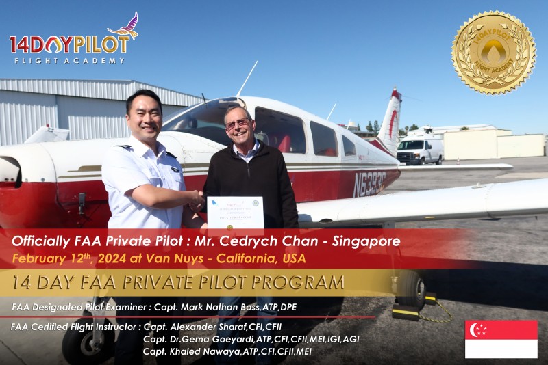
Mr. Cedrych from Singapore achieved his Private Pilot License within 14 days of training.
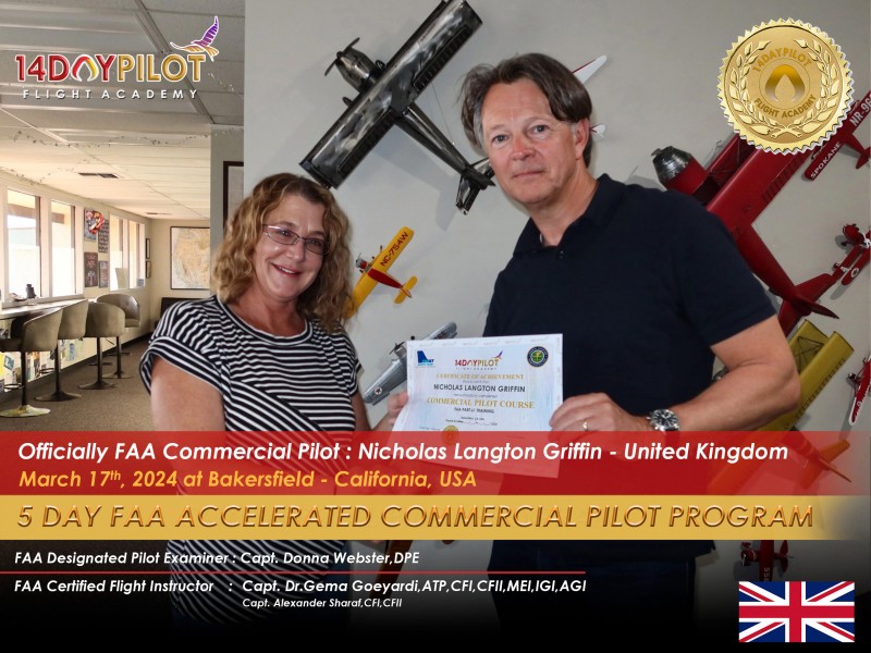
Mr. Nicholas from the UK achieved his Commercial Pilot License in just 5 days of training.

Mr. Keith from Singapore achieved his Private Pilot License within 14 days of training.
Contact us now to start your journey! Reach us at USA: +1 747 777 9552
or
email us at info@14daypilot.com
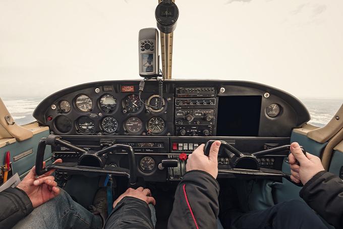
Pilots prioritize safety through meticulous flight planning that considers weather, terrain, and routing. While summer offers ideal weather in Los Angeles for flight training, understanding density altitude, a major aviation hazard caused by hot temperatures and high elevations, remains crucial. Imagine planning a camping trip from LA to Lake Tahoe by renting a plane from Van Nuys. To ensure a safe take-off at maximum weight due to your friends and camping gears, understanding density altitude is a must. Density altitude is a critical parameter used in aviation to assess aircraft performance.
"Density Altitude" represents the altitude in the International Standard Atmosphere (ISA) where the air density would be the same as at the actual location, considering temperature and pressure variations. In simpler terms, density altitude is the altitude at which the aircraft "feels" as if it's flying, concerning its performance, rather than its actual physical altitude above sea level.
What does it affect? Think CALT: Climb Rate, Airspeed, Landing distance, Take-off distance. Climb rate will decrease as the temperature increases. The true airspeed will be higher due to increased temperature as well. Landing distance & Take-off distance will also increase incrementally with temperature. These combined is the perfect recipe for a disaster, but there is a way to avoid this:
Now, this is how I teach students in the 14 DAY ACCELERATED PRIVATE PILOT TRAINING PROGRAM by 14DAYPILOT Flight Academy on how to calculate density altitude and avoid disaster:
The density altitude (DA) is calculated using the following formula:
DA = PA + [120 x (OAT - ISA)]
Where:
- PA is the pressure altitude (the altitude corrected for non-standard pressure).
- OAT is the outside air temperature in degrees Celsius.
- ISA is the International Standard Atmosphere temperature for the given altitude.
To calculate density altitude, we first need to determine the pressure altitude. This can be done using a standard altimeter setting or by using actual pressure readings and a conversion chart.
Let's take Lake Tahoe as an example. The elevation of Lake Tahoe Airport (KTVL) is approximately 6,264 feet (1,909 meters) above sea level.
- Check the current altimeter setting (local barometric pressure) at Lake Tahoe Airport or nearby. Let's say it's 28.50 inches of mercury (Hg).
- Convert this setting to inches of mercury: 28.50 inHg.
- Use this value to find the pressure altitude using a conversion chart or formula. For simplicity, you can use an online calculator or chart. Let's assume the pressure altitude is calculated to be 7,000 feet.
- Find the current outside air temperature (OAT) at Lake Tahoe. Let's say it's 15°C.
- The ISA temperature decreases by approximately 2°C for every 1,000 feet increase in altitude. At 7,000 feet, the ISA temperature would be around 1°C.
- DA = 7,000 + [120 x (15 - 1)]
- DA = 7,000 + [120 x 14]
- DA = 7,000 + 1680
- DA ≈ 8,680 feet
In this example, this means that despite being at a physical altitude of 6,264 feet, the aircraft will perform as if it were at an altitude of 8,680 feet due to the combination of temperature and pressure effects on air density. Pilots must consider density altitude carefully to ensure safe take-offs, landings, and overall flight performance, especially in areas with high elevations like Lake Tahoe.
Now that we know the density altitude, let’s do the performance calculations for your flight back from Lake Tahoe with 2 friends. You’ll be flying the Piper Warrior II, we’ll do the Weight & Balance first. With 2 passengers, and 100 lbs of combined luggage & camp gear this is how it looks:
As you can see, you’ll be very close to your Maximum Takeoff Weight & on the limits of the Center of Gravity for the aircraft. Combined with the density altitude, this will affect the performance of the aircraft significantly.
Now, let’s do your takeoff calculations. You’re going to be on max takeoff weight, with a temperature of 15 degrees C, pressure altitude of 7000 ft, and density altitude close to 8680 feet. The performance charts for the Piper Warrior II are quite easy to use, you have to draw lines based on the information that you currently have, let’s take a look:
First, you’ll take the OAT of Lake Tahoe which is 15 degrees C, draw a line upwards to the 7000 ft pressure altitude, then draw a line upwards from your takeoff weight of 2438 lbs, then another line horizontally to connect both lines. At the point they are connected, you then draw another horizontal line all the way towards the right to find out takeoff ground roll is 2550 ft. And this is being optimistic, assuming there are no wind activities in Lake Tahoe! Next, you’ll have to do the climb rate calculations to 10,000 Ft to clear the mountains around Lake Tahoe.
Same concept here, you’ll first draw a line upwards from 15 degrees C to our pressure altitude of 7000 Ft. Then horizontally to meet the reference line, and we get a climb rate of 220 Feet per Minute (FPM). Would you look at that! While we are able to takeoff from Lake Tahoe, it would certainly be hazardous to try clearing the mountains if we’re climbing at 220 FPM. This would immediately set off red flags for me to not do this flight & wait for better weather to get better performance before flying back. As the Pilot-in-Command (PIC) of this flight, I’ve made a decision that this flight is a NO GO due to poor climb performance. But let's take a look at the Time, Fuel and Distance to Climb chart:
Same concept, but here we need to do 2 colored lines: First line (Red) is the departure airport calculation, Second line (Green) is for the cruising altitude. Let's do the departure airport first. I would first draw a line vertically from the 15 degrees C line since that is our temperature for Lake Tahoe, then meet the pressure altitude line of 7,000 Ft. After that, draw a horizontal line until the line intersects the Fuel, Time & Distance lines respectively. Mark the points at which our horizontal line intersects with the Fuel, Time & Distance lines, draw a line straight down to get the results. Do the same process for our cruising altitude of 10,000 Ft.
Departure Airport:
Fuel : 4 Gallons
Time : 20 Minutes
Distance : 28 NM (Nautical Miles)
Cruising Altitude:
Fuel : 6 Gallons
Time : 31 Minutes
Distance : 44 NM
Fuel : 6 Gallons - 4 Gallons = 2 Gallons
Time : 31 Minutes - 20 Minutes = 11 Minutes
Distance : 44 NM - 28 NM = 16 NM (Nautical Miles)
Based on this chart, it will take us 11 minutes to reach our cruising altitude of 10,000 Ft from the departure airport pressure altitude 7,000 Ft, spend 2 Gallons of fuel during the climb, and take 16 NM of distance.
While there are many other performance calculations that needed to be done before the flight, looking at the climb performance of 220 FPM would already make me stop right there and wait for better weather. It would be hazardous to the safety of this flight, and jeopardizing the safety of me & my friends would be the last thing I’d like to do.
At 14DAYPILOT Flight Academy, we specialize in assisting numerous pilots in obtaining their FAA license within just 14 days and achieving outstanding results in their examinations. Our comprehensive flight training program covers Private Pilot, Instrument Rating, Commercial Pilot, Multi Engine Rating, and Airline Transport Pilot Professional courses. Backed by highly qualified FAA Gold Seal CFIs, we are dedicated to providing the finest pilot training available. Located in the Los Angeles Area, our academy boasts a stellar program, featuring highly motivated instructors, a well-structured curriculum, and meticulously maintained aircraft. We are committed to helping you obtain your license in a significantly shorter timeframe compared to other flight schools.
Let’s make your aviation dream come true like the success stories of our students!
Mr. Cedrych from Singapore achieved his Private Pilot License within 14 days of training.
Mr. Nicholas from the UK achieved his Commercial Pilot License in just 5 days of training.
Mr. Keith from Singapore achieved his Private Pilot License within 14 days of training.
Contact us now to start your journey! Reach us at USA: +1 747 777 9552
or
email us at info@14daypilot.com
Dr.Gema Goeyardi as a Gold Seal flight instructor will help you to achieve your dream as a pilot in a fast track accelerated program. His secret recipe of accelerated flight training syllabus has proven to graduate pilots from Private Pilot to ATP world wide in just very short days. As an ATP and Boeing 737 captain he always set a high standard of training and encouraged all students to have a professional pilot qualification standard. Lets talk with Dr.Gema for your training program plan, schedule your check ride, and customize your flexible training journey.
Dr.Gema Goeyardi as a Gold Seal flight instructor will help you to achieve your dream as a pilot in a fast track accelerated program. His secret recipe of accelerated flight training syllabus has proven to graduate pilots from Private Pilot to ATP world wide in just very short days. As an ATP and Boeing 737 captain he always set a high standard of training and encouraged all students to have a professional pilot qualification standard. Lets talk with Dr.Gema for your training program plan, schedule your check ride, and customize your flexible training journey.

The DPE checkride is more than just flying, it’s about mindset, decision-making, and professionalism. Learn what examiners really...

Discover Capt. Gema’s inspiring journey flying into Oshkosh AirVenture, the world’s busiest airport for a week. Learn what ...

Prepare for your checkride oral exam with confidence. The POES Coaching Program by 14DAYPILOT helps you master concepts, think like a p...
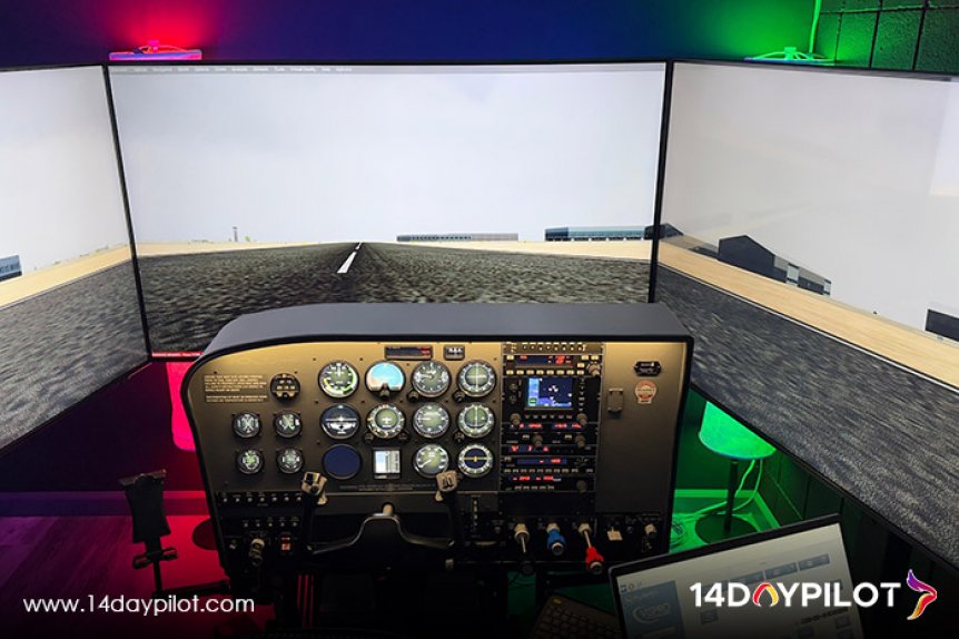
AATD flight simulators help future pilots train faster and smarter with FAA-approved, realistic practice on the ground. From mastering ...
Dr.Gema Goeyardi as a Gold Seal flight instructor will help you to achieve your dream as a pilot in a fast track accelerated program. His secret recipe of accelerated flight training syllabus has proven to graduate pilots from Private Pilot to ATP world wide in just very short days. As an ATP and Boeing 737 captain he always set a high standard of training and encouraged all students to have a professional pilot qualification standard. Lets talk with Dr.Gema for your training program plan, schedule your check ride, and customize your flexible training journey.